WATKINS (LY2794)
WATKINS
Note Entered on November 21, 2007
Spatial/elevation data
| Coordinates | N 41.588906° W 75.724568° |
| Elevation | 1325 ft. |
| Location | Pennsylvania
Lackawanna County Dalton Quad |
Mark description
| Type | Triangulation Station Disk |
| Setting | Square Concrete Monument |
| Monumented | 1929 by NGS |
| Description (NGS) | NGS Datasheet |
Narrative and photographs
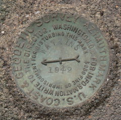
It seems likely that this mark and its associated reference marks are still in place. Although there is now a house nearby, the area around the marks appears wooded and untouched. We have not yet asked for permission to search the area, however. We did search for, and recover, the azimuth mark because it is easily accessible alongside a road.
| Designation | Status | Condition | Image |
|---|---|---|---|
| WATKINS AZ MK | Recovered | Fair |
|
| WATKINS RM 1 | Note Entered | Unknown (Not Found) |

|
| WATKINS RM 2 | Note Entered | Unknown (Not Found) |
|