HIGGINS
Spatial/elevation data
| Coordinates | N 44.388899° W 68.368658° |
| Elevation | 131 ft. |
| Location | Maine
Hancock County Salsbury Cove Quad |
Mark description
| Type | Copper Bolt |
| Setting | Rock Outcrop |
| Monumented | 1865 by NGS |
| Description (NGS) | NGS Datasheet |
Narrative and photographs
Previous recovery (June 13, 2005): see HIGGINS.
When I looked this morning at the datasheet for HIGGINS, I was surprised to see that there was a relatively recent recovery, from 2019 - and even more surprised to read that the contributor was unable to find the station mark (a bolt) or reference mark 1. When I mentioned this to Rich, our plans changed a bit, from just a simple walk to the shore at Blagden Preserve, to trying to recover the triangulation station again. Turns out it was trickier than we could have imagined!
I seem to have much better phone reception on the island this year, and I had no trouble pulling up the datasheet for HIGGINS and entering the coordinates in my GPSr so we could begin our search. After a short walk along the preserve’s beautiful fern, moss, and hemlock-lined road, we reached the coordinates. But this area looked entirely different from what we remembered!
Let’s look around some more, we thought: these wooded locations can often be deceiving. We didn’t see anything that resembled the rock with the bolt set into it, and the woods were much thicker than we recalled.
I brought up the HIGGINS page on my website and we looked at the photos. Wow … this area looks almost nothing like it did in 2005! I began to realize that this was going to take some serious work.
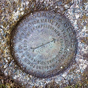
But first, we thought we’d try to find the reference marks. One was set on a large, tall boulder and the other was set in a concrete monument projecting several inches, so we thought we might have a better chance at finding them, and then working backwards (forwards?) from the reference marks to find the station - technically, using the reference marks as references, as they were intended.
It took a few more minutes and more checking of our previous photos, but then I spotted the monument holding RM 2. The entire monument was thickly covered in moss, soil, and pine needles, but the square shape of the monument was unmistakable once I noticed it.
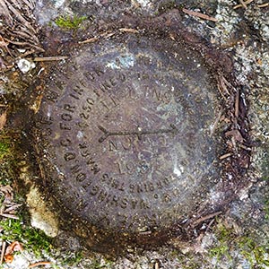
Then we turned our attention to RM 1. According to the description and our earlier photos, it was set on the very top of a large, rounded boulder projecting at least two feet above the ground. Should be easy to find, right? Well, again, such heavy growth of young pines and spruce have grown up in this area that it was hard to even find the boulder, let alone to reach it! The first boulder we spotted from the road wasn’t the one containing the mark, but it is currently obvious enough that we can use it as a “reference boulder,” if you will, for the boulder holding the actual reference mark. The boulder you want is just a few yards east of the first obvious, large boulder when coming into the woods from the road.
The shape of the correct boulder was unmistakable once I saw it, but it was a chore to get to and to clean off the disk. Little did we know what we had in store for us when we started to look in earnest for the station mark itself!
When I was at RM 1, Rich began to poke around in the area where we expected to find the station mark, given the coordinates. (Keep in mind that this entire area looks completely different from how it looked in 2005.) The idea was that I would tell him when he was lined up with the arrow on the reference mark, and we would estimate the distance of 7.3 meters as well as possible in an area that was nearly impossible to walk around in.
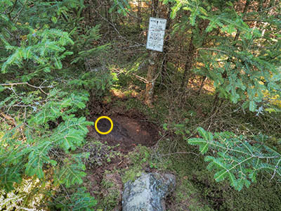
Rich marked the spot where I indicated that he was in line with the arrow, and right away he said that he had found the witness sign! But the tree it was attached to, that had been alive and solid 19 years ago, was now rotted at the base, and the tree had fallen over. He could still tell where it had been attached to what remains of the stump.
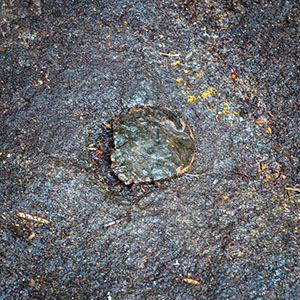
I worked my way over to where he stood, and we began our search by comparing what we saw and the approximate location of the witness sign with our photos from 2005. It was so hard to believe the transformation in this area! It is all so thickly overgrown now. In 2005, the rock at the base of the tree where the mark was set was bare, and the bolt stood out from a distance. Today, we couldn’t even see the rock. We dug and dug through layers of moss, soil, and a rotted tree, and eventually Rich said that he thought he had struck rock.
We figured that had to be the correct rock since it appeared to be the only one anywhere near the witness tree. But it still required ten minutes of digging to clear the rock, and even then, a few more minutes to clean off the last layer of soil well enough that we could see and positively identify the bolt. It was a thrilling re-recovery, and yet another reminder of how quickly things can change. (And yet there is that bolt from 1865, quietly sitting all these years in the same place, and still findable by us today.)
Concerning the mark’s history, we later found the original description for HIGGINS in the U.S. Coast & Geodetic Survey Special Publication 46 “Triangulation in Maine”. It states:
Higgins (Hancock County, G. A. F., 1865).—On the north side of the hill on Indian Point, west side of Mount Desert Island, about 1¾ miles west by south from Town Hill. The station is about ¼ mile from the end of the point, ⅛ mile from the shore of Clarks or Northwest Cove, and ½ mile north of the west shore road. A branch road to Indian Point passes close to the station, which is marked according to note 18.¹ The land then belonged to Sylvanus Higgins.
Note that Note 18 as specified in this publication is not the same as Note 18 in the more recent Manual of Geodetic Triangulation, which refers to azimuth marks. Here, Note 18 is:
Note 18.-A copper bolt set in a hole in the rock, (a) and surrounded by a triangle cut in the rock, (b) and covered by a cairn, (c) and surrounded by a circle.
| Designation | Status | Condition | Image |
|---|---|---|---|
| HIGGINS RM 1 | Recovered | Good |

|
| HIGGINS RM 2 | Recovered | Good |

|

