TT 1 J
Spatial/elevation data
| Coordinates | N 41.27615° W 75.507003° (estimate) |
| Elevation | Unknown |
| Location | Pennsylvania
Lackawanna County Moscow Quad |
Mark description
| Type | Transit Traverse Station Disk | ||||||
| Setting | Rock Outcrop | ||||||
| Monumented | 1926 by USGS | ||||||
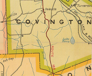
| Description (USGS) | Daleville, 2.0 mi S. of; 30 ft E. of State Highway 168; between telephone poles 4425 and 4426; in rock outcrop; standard tablet stamped “TT STA NO 1 J 1926”
|
Narrative and photographs
The coordinates put this mark very close to 36 JPN, which we did find. I was looking forward to finding this one because all of the TT [x] J series we’ve found so far have been disks made of Aich’s metal, a beautiful sparkling gold-colored alloy that resists tarnish. We spotted a few likely outcrops on Google Street View, but when we arrived on the site, I wasn’t able to find the disk on any of those outcrops or anywhere else nearby. There isn’t much to go on (the coordinates from the USGS datasheets are sketchy, often quite far off—in this case, they put the mark on the wrong side of the highway) and the utility poles now sport new numbers, so I’m not even certain we were looking in the correct spot. Perhaps a late fall or winter day when the vegetation is down would allow for a more thorough search of the area. At that time we also might want to expand the search a distance up and down the highway.
Update (April 2025): Originally I was confused by the mention of State Highway 168, because I could find no reference to this route number on PAHighways.com, which is generally a reliable resource. However, I just checked the Historic Type 10 Lackawanna County map from 1923, and I see that the route was in fact Route 168.

