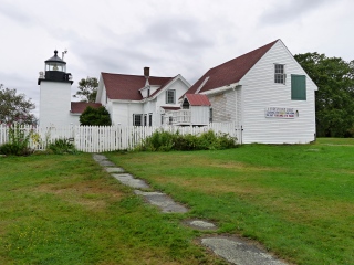
FORT POINT LH
Spatial/elevation data
| Coordinates | N 44.467135° W 68.811687° |
| Elevation | Unknown |
| Location | Maine
Waldo County Castine Quad |
Mark description
| Type | Landmark/Intersection Station |
| Setting | Lighthouse |
| Monumented | Unknown by NGS |
| Description (NGS) | NGS Datasheet |
NGS recovery information
Descriptive text
Recovered in good condition.Narrative and photographs
Rich and I visited Fort Point on last year’s trip to Maine, but for some reason, I neglected to take a photo of the lighthouse. I found out later that the lighthouse was, of course, a landmark station (the same thing happened with FORT POINT LEDGE BEACON). We were prepared this year, however, and easily made the “recovery.”
The present lighthouse was built in 1857, and it remains an active U.S. Coast Guard navigation aid. Also on the grounds are a fog bell tower, a barn, and an oil house.
