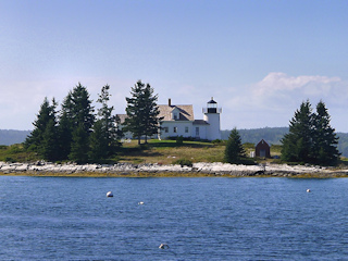
PUMPKIN ISLAND LIGHTHOUSE
Spatial/elevation data
| Coordinates | N 44.309165° W 68.742873° |
| Elevation | Unknown |
| Location | Maine
Hancock County Sargentville Quad |
Mark description
| Type | Landmark/Intersection Station |
| Setting | Lighthouse |
| Monumented | Unknown by Unknown Agency |
| Description (NGS) | NGS Datasheet |
NGS recovery information
Descriptive text
Recovered in good condition.Narrative and photographs
Little Deer Isle resident Peter Bell, whom we had met at LITTLE DEER ISLE RESET, gave us a tip on viewing the lighthouse. According to him it’s easy to see the Pumpkin Island Lighthouse from several places on the northwestern end of Little Deer Isle, as we had hoped. What we weren’t expecting was the stunning view of the lighthouse from Eggemoggin Road. There is even a pull-off for easy parking and an outcropping ledge that serves as the perfect platform for photography. The structure including the tower appears to be in excellent condition. The lighthouse was built in 1854 and operated until 1933, when it was taken out of service as an active aid to navigation. It is currently a private residence.
