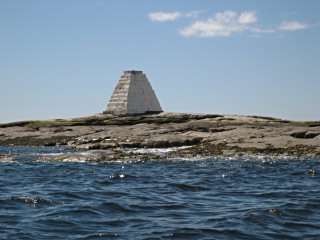
BUNKER LEDGE MONUMENT
Spatial/elevation data
| Coordinates | N 44.27993° W 68.22305° |
| Elevation | Unknown |
| Location | Maine
Hancock County Seal Harbor Quad |
Mark description
| Type | Landmark/Intersection Station |
| Setting | Pyramid |
| Monumented | Unknown by Unknown Agency |
| Description (NGS) | NGS Datasheet |
Narrative and photographs
The Bunker Ledge Monument is one of the most unusual landmark stations I’ve recovered. Before indulging in a lobster lunch at Beal’s, Rich and I enjoyed a lazy morning nature cruise in the sunshine that took us past Bear Island Lighthouse (PE1907), to Islesford, and eventually into Somes Sound. While cruising around, we used my GPSmap76CS to identify a number of navigational aids as we passed them, such as green and red cans, red nuns, and of course the Bunker Ledge Monument.
We were tempted to submit a recovery to NGS because it’s been over 50 years since the last one, but we eventually decided not to. While it is extremely likely that the white pyramid is the monument referred to, it is not certain because the recovery notes contain no description of it. It is possible, however unlikely, that the original monument on this sea ledge was actually something entirely different.
