TIDAL 3 STA 31
Spatial/elevation data
| Coordinates | N 44.425028° W 68.99908° |
| Elevation | 10.05 ft. |
| Location | Maine
Waldo County Belfast Quad |
Mark description
| Type | Drill Hole |
| Setting | Rock Outcrop |
| Monumented | Unknown by NGS |
| Description (NGS) | NGS Datasheet |
NGS recovery information
Descriptive text
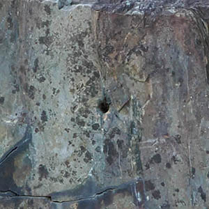
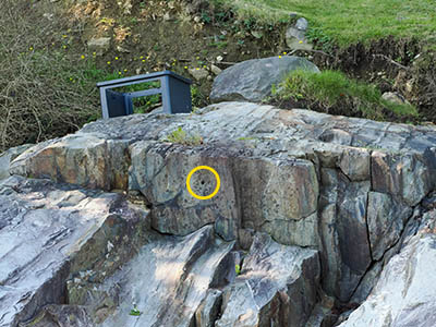
Recovered in good condition on the northeast face of a prominent rock outcrop. Hole is drilled horizontally into the face of the outcrop. The drill hole is about 6 feet north of Tidal 7 (PE0904), which is set in the top of the same outcrop. Mark is about 400 ft SE of the S corner of the Belfast Boathouse (formerly the site of the Wyman Lumber Company), and about 290 ft SE of the SE corner of a timber retaining wall at the boathouse. Mark can be accessed from the beach at low tide. It is also accessible from the private property to the south. Note - the former U.S. Highway 1 bridge over the Passagassawakeag River is now a pedestrian bridge. in 1963 A new highway bridge was built several hundred feet to the north of the former highway bridge.Narrative and photographs
Well, this was a weird one! I had mentioned to Rich that in addition to the two tidal station disks in this location, there was also supposed to be a drill hole. Drill holes are usually very tricky to find as they easily become overgrown, filled in with water and mud, and when eroded are difficult to positively identify. But I thought I would climb back up the large rock outcropping on which I had found TIDAL 7 STA 31 (PE0904), rather quickly this time as the tide was coming in rapidly, and do a quick search. After all, the drill hole was supposed to be only 6 feet from TIDAL 7! And drilled in vertically, which to us meant drilled downward from the top of the ledge.
But I didn’t spot anything at the time. There was a large crack in the top of the ledge that was filled with water and mud and sprouting vegetation. I figured it was possible the drill hole was in that crack somewhere.
Rich alerted me that the tide was coming in quickly, so I scrambled back down the ledge, having to skirt around much closer in to the shore because the bottom of the ledge was already in water a few inches deep. Oh well, we had found two of the markers, and there were some others in town to look for, so we left relatively satisfied.
It wasn’t until later that evening while I was writing up my daily notes that I decided to take another look at the datasheet for the drill hole. While it says “Drilled in vertically,” I wondered if they may have meant “in the way a hole would be drilled for a disk set vertically.” So, actually horizontally, into the face of the ledge rather than into its top. I took another look at the photo of TIDAL 7 taken from a distance, that shows the whole ledge, and wouldn’t you know it, there was the damned drill hole, drilled horizontally into the ledge.

