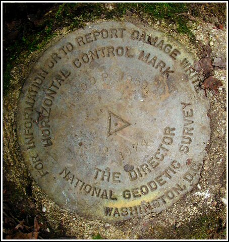
THROOP (LY2731)
Spatial/elevation data
| Coordinates | N 41.435707° W 75.626033° |
| Elevation | 1042 ft. |
| Location | Pennsylvania
Lackawanna County Scranton Quad |
Mark description
| Type | Triangulation Station Disk |
| Setting | Square Concrete Monument |
| Monumented | 1959 by NGS |
| Description (NGS) | NGS Datasheet |
NGS recovery information
Descriptive text
The station mark and reference marks 1 and 2 were recovered in good condition. The site can be accessed by following a jeep trail southerly from its intersection with Olyphant Avenue at 41 26 36.1(N) 075 37 36.8(W). After about 0.5 mi (0.8 km) pack southeasterly up the knoll toward the station. A metal post was set in the ground roughly in accordance with the witness post described in the 1974 recovery note.Narrative and photographs
Finding this set of marks was a two-day adventure for me (three days for Rich, but the first day was planned only as a scouting expedition for him). Early on the morning of the 18th, we met at the start of the jeep trail just off of Olyphant Avenue. I hopped into Rich’s car (the more rugged of the two) and we drove in about 1/4 mile, as far as he felt comfortable. We approached the mark on foot through dense woods and brush. The station mark was easy for me to locate because Rich had unearthed it and cleaned it off just days before. The reference marks, however, gave us more of a challenge; the historic descriptions did not match what we found in the area, and we could not reconcile some of the measurements. We attempted to position a stake in the location of the second witness post (in accordance with the 1974 description) and we took our measurements from that point. We took great pains to measure the distances and directions and probe the earth, but for two hours we came up with nothing. Just as we realized the hour was getting late and we needed to leave, Rich’s probing paid off and he uncovered RM 2 at approximately the distance noted (in 1974) from what remains of the cherry tree.
On the 19th we decided to tackle THROOP once more, and this time we were more optimistic as I’d found some measurements on the official datasheets that I expected would help us locate RM 1. We measured out the distances and angles and found the mark almost immediately, though it was buried under several inches of soil thanks to the woodchucks who have made their home adjacent to the post. All three disks are in excellent condition with all stamping legible, and have been cleared of mud and moss. The 1974 description errs in stating that RM 1 is 17 feet west of the witness post; the actual direction is nearer southeast.


[Log from 13 August 2003]:
This note is to indicate a “work in progress” since I was able to locate the station mark but not the two associated reference marks. There appears to be a significant discrepancy in the 1974 historical description regarding the placement of the reference disks in relation to a (no longer existing) witness post and the station mark. I intend to return soon with a complete set of NGS datasheets and proceed from the older recoveries in hopes of locating RM1 and RM2. ~Rich in NEPA~
[Log from 18 August 2003]:
Had to bring in the big guns today. This morning RM2 was uncovered with assistance from Zhanna (Queen of Benchmarks), and the mark seems to correlate with the 1974 description. Armed with some new insights from the NGS datasheets I will return for RM1, and hopefully complete the find and the documentation.
[Log from 19 August 2003]:
To reach this second order horizontal control station it was necessary to access a jeep trail going south off Olyphant Avenue near the I-81 overpass, coordinates: N41° 26.602’ W075° 37.614’. It was possible to drive along the trail for about 1/4 mile and continue on foot another 1/4 mile to the edge of a wooded knoll, and then bushwhack through moderately dense brush to the site. The 1974 historical description was reliable enough to locate the area of the station mark, but following the GPSr to the listed coordinates was more helpful. The witness post no longer exists, and the station mark itself was concealed by a layer of dirt, leaf litter and sticks. At the station mark a Garmin GPSmap76 receiver indicated 4.6 feet from the adjusted NGS datasheet coordinates. Locating the two reference marks was a much more difficult task for the following reasons. Both the 1974 and 1959 descriptions are in error and were extremely misleading. The dim track road that was referred to has vanished completely. It seems that over the years a woodchuck or two has taken the liberty of burying RM1 under 3 to 4 inches of tailings from its den-building activities. Also, RM2 was covered by a natural accumulation of dirt, moss, sticks and dead leaves. The area around each of the marks was scraped clear and the settings are now well exposed. All three disks are in very good condition, and the stamped designations are legible. As a final act in the completion of this amateur benchmark recovery a new witness post was placed in accordance with the 1974 description. ~Rich in NEPA~


| Designation | Status | Condition | Image |
|---|---|---|---|
| THROOP RM 1 | Recovered | Good |
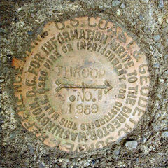
|
| THROOP RM 2 | Recovered | Good |
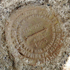
|