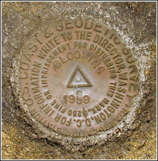
BLOOMING (LY1222)
BLOOMING
Spatial/elevation data
| Coordinates | N 41.351166° W 75.1324° |
| Elevation | 1627.01 ft. |
| Location | Pennsylvania
Pike County Promised Land Quad |
Mark description
| Type | Triangulation Station Disk |
| Setting | Square Concrete Monument |
| Monumented | 1959 by NGS |
| Description (NGS) | NGS Datasheet |
NGS recovery information
Descriptive text
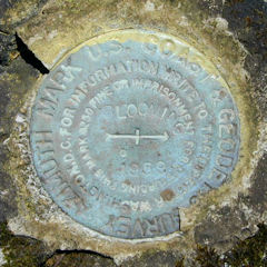
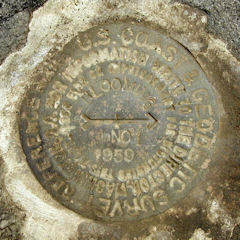
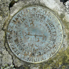
The station mark, both reference marks, and the azimuth mark were recovered in good condition. The station mark is flush with the ground. The 8-inch triangular blazed maple tree was not found. The 10-inch triangular blazed oak tree is dead but still stands and the blaze is barely discernable. The witness sign at the station still exists. Handheld GPS WAAS-corrected coordinates for the azimuth mark are 41 21 2.46(N) 075 07 53.16(W). The station, reference marks, and azimuth mark are located on the property of the Blooming Grove Hunting and Fishing Club. Contact information - Scott F. Savini, General Manager, HC 8 Box 8066, Hawley, PA 18428, 570-775-7371.Narrative and photographs
Having already obtained permission to search for marks on Blooming Grove Hunting Club property, I was anxious to get started on some of the tri-stations in the area. We parked at the end of the gated woods road at its intersection with Route 402 and hiked the woods road toward the station. After only about 100 yards, Rich happened to look into the woods to our right and he noticed the azimuth mark set in a boulder just off the side of the road. With this part of our search complete (although somewhat by accident), we set off to find the station and reference marks. Another few hundred feet up the woods road and then directly southwest into the open woods brought us directly to the witness post, from which we measured and dug to unearth the station monument and mark. The reference marks were similarly straightforward to locate following the original description. We searched for and, surprisingly, were able to locate the blaze on one of the old oak trees about 26 feet southeast of the station! The cut blaze is faint, but still distinguishable as a triangle. We photographed these marks and took relevant measurements, and then retraced our steps back to the azimuth mark where we did the same. The marks are all in good condition, with legible stamping.


Station recovered in good condition.
This second order triangulation station is situated on a low wooded knoll on property owned by the Blooming Grove Hunting & Fishing Club. The 1959 “to reach” directions are still usable. The azimuth mark is on the right roughly 150 yards north-northwest of the gate across the private track road off Rt. 402. The blazed maple tree was not found. To reach the station, travel roughly an additional 100 yards along the track road beyond the azimuth mark, then turn southwest directly into the brush for about 40 yards. The blazed oak tree on the right side of the track road was not found. A handheld GPS receiver was helpful in pinpointing the location of the station.
The station and its two reference marks were found as described. The station mark is set in the top of a concrete monument about level with the ground, and 7.1 feet east of the witness post and sign. The triangular-blazed oak tree southest of the station was found but the tree is now dead and the large cut blaze is hardly distinguishable. RM 1 is east-northeast of the witness post, and about 4 inches above ground level. RM 2 is south-southeast of the witness post, it is well exposed and set in the top of an outcropping rock.
At the station a Garmin GPSmap76 receiver with active remote antenna was used to record autonomous (non-corrected) coordinates which were identical (within 0.001 minute) to the adjusted coordinates listed on the NGS datasheet. All marks are in good condition and the stamped designations are legible.


| Designation | Status | Condition | Image |
|---|---|---|---|
| BLOOMING AZ MK | Recovered | Good |
|
| BLOOMING RM 1 | Recovered | Good |
|
| BLOOMING RM 2 | Recovered | Good |
|