S 235
Spatial/elevation data
| Coordinates | N 41.329167° W 75.126116° (estimate) |
| Elevation | 1441.59 ft. |
| Location | Pennsylvania
Pike County Promised Land Quad |
Mark description
| Type | Survey Mark |
| Setting | Bridge Abutment |
| Monumented | 1959 by PA Dept. of Highways |
| Description (NGS) | NGS Datasheet |
NGS recovery information
Descriptive text
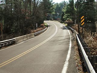
Mark not found. According to PennDOT’s bridge survey database this bridge was rehabilitated in 1980. The wingwalls have been capped with new concrete.Narrative and photographs
Rich and I were unable to locate this mark. PennDOT’s historic bridge survey database records this bridge as having been rehabilitated since the mark was placed. The text states: “The 36’-long T beam bridge built in 1932 is supported on reinforced concrete abutments with wingwalls. It is finished with safety shape concrete parapets from 1980, when the substructure was also rehabilitated.” (The database can be downloaded from the PennDOT Cultural Resources Management Program Web Site.)
Mark not found.
This second order vertical control station is described as being set in the top surface of the east wingwall of the south abutment of a highway bridge over Notch Brook. The historical description leads reliably to the site. However, the mark was not found. There is visible evidence that this structure was renovated since the station was monumented, the wingwalls having been capped with additional concrete. In the top of the southwest corner of the south end of the west concrete guard wall a chiseled square was found. ~Rich in NEPA~

