J 257
Spatial/elevation data
| Coordinates | N 40.334419° W 75.923941° (estimate) |
| Elevation | 263.48 ft. |
| Location | Pennsylvania
Berks County Reading Quad |
Mark description
| Type | Bench Mark Disk |
| Setting | Concrete Slab |
| Monumented | 1960 by NGS |
| Description (NGS) | NGS Datasheet |
NGS recovery information
Descriptive text
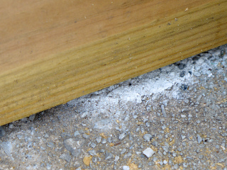
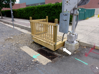
Mark not found. A wooden platform has been built over the northern edge of the signal base. The bottom of the platform is nearly flush with the surface of the signal base, so the area where the mark was set is entirely concealed. It was not possible to confirm whether the mark is still intact.Narrative and photographs
Following the WWII Days air show at Reading’s Mid-Atlantic Air Museum, Rich, Dad and I drove deeper into the city of Reading for supper at the Speckled Hen. I had not planned on searching for any survey marks today, but while we waited for our meals to arrive at the table, I checked BenchMap. There were a few marks nearby that looked easy enough.
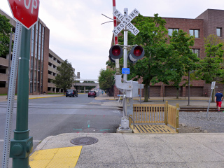
J 257 was the first. We drove to the intersection of Cherry and N. 7th Streets. The railroad tracks run parallel to N. 7th and it’s easy to access the railroad crossing signal. Rich stayed to watch the car while Dad and I walked over to the railroad signal at the crossing. Instead of the disk we expected to find, we instead saw a newly-constructed wooden platform erected right over the mark. I checked the existing logs for this mark at Geocaching.com and confirmed that the disk’s location was on the northwest corner of the signal base—just underneath the south edge of the new platform. Try as we might, Dad and I could not get a glimpse of the disk, and the platform base nearly touches the concrete signal base, so I couldn’t even slide my finger underneath to feel for the disk. While it is highly likely that the bench mark disk is still in place, I can’t confirm that. The most recent find logged on Geocaching.com was from last July, so the platform must have been built within the last 11 months.


