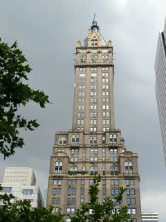
MANHATTAN NR SE CEN PK T BLDG
Spatial/elevation data
| Coordinates | N 40.764342° W 73.972596° |
| Elevation | Unknown |
| Location | New York
New York County Central Park Quad |
Mark description
| Type | Landmark/Intersection Station |
| Setting | Building Spire |
| Monumented | 1932 by NGS |
| Description (NGS) | NGS Datasheet |
Narrative and photographs
Today’s long walk around the city wrapped up with a stroll through Central Park, where we found one of the original Manhattan survey bolts and a few nearby landmark stations. This large apartment-hotel, The Sherry-Netherland, was one of the landmarks. Built in 1927 in the Romanesque Revival and Gothic Revival styles, it was the tallest apartment-hotel in New York City when it opened. A previous building on the site, the Hotel New Netherland, burned in a spectacular fire in 1927 while it was already undergoing demolition. Although the building referred to in the datasheet description is not named, it must have been the current building because it was first observed in 1932.
