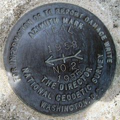
TEAL RESET
Note Entered on September 2, 2003

Spatial/elevation data
| Coordinates | N 38.350839° W 75.083412° |
| Elevation | 4 ft. |
| Location | Maryland
Worcester County Ocean City Quad |
Mark description
| Type | Horizontal Control Disk |
| Setting | Square Concrete Monument |
| Monumented | 1958 by NGS |
| Description (NGS) | NGS Datasheet |
Narrative and photographs
I suspect this station is still viable, but it is on private property and I wasn’t comfortable enough to attempt to search for it, nor did I see anyone nearby to ask for permission.
I was able to find the azimuth mark, which is set into the curb along a public street north of the station. The azimuth is in good condition and is easily accessible.
| Designation | Status | Condition | Image |
|---|---|---|---|
| TEAL AZ MK 2 | Recovered | Good |
|