PIER A
Spatial/elevation data
| Coordinates | N 24.558409° W 81.808393° |
| Elevation | 7 ft. |
| Location | Florida
Monroe County Key West Quad |
Mark description
| Type | Survey Disk |
| Setting | Concrete Pier |
| Monumented | 1981 by National Ocean Service |
| Description (NGS) | NGS Datasheet |
NGS recovery information
Descriptive text
Mark not found. Area is now covered with concrete.Narrative and photographs
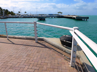
While on our morning stroll around Key West, we checked the pier for two marks that we had little hope of finding. After checking the northern side of this pier for IVY 1935, we checked the southwestern corner in hopes of spotting something relating to PIER A. The promenade is covered in relatively new concrete and bricks and it seems likely that the mark was simply covered at that time. We used both the adjusted coordinates and the measurements from reference objects in the description. As expected, both brought us to the same spot but neither offered enlightenment. In our opinion, the mark is probably still in place but not easily accessible or usable at this time. (There is a temporary mark, a nail with a washer, near the coordinates, but this appears to have no connection to PIER A.)

