BUNCH
Spatial/elevation data
| Coordinates | N 24.599613° W 81.587817° |
| Elevation | 2 ft. |
| Location | Florida
Monroe County Saddlebunch Key Quad |
Mark description
| Type | Triangulation Station Disk |
| Setting | Square Concrete Monument |
| Monumented | 1935 by NGS |
| Description (NGS) | NGS Datasheet |
NGS recovery information
Descriptive text
The prairie and access roads leading toward the mark are now submerged, possibly due to this year’s record rainfall. The marks are probably still in place but would be difficult or impossible to access at this time.Narrative and photographs
Challenging tri-station hunts are few and far between in the Keys. Most survey marks in this area are benchmarks, specifically tidal benchmarks, which makes perfect sense given the amount of coastline and road/bridge infrastructure. The tri-stations that exist here seem to be set alongside the road (which is fine, but those are usually not as interesting or challenging), or were long ago lost to development or the elements. But when we were investigating Sugarloaf’s old highway trail, we spotted BUNCH nearby on the topo map. Immediately we put it on our list. You can never be sure in the Keys, but satellite imagery showed what appeared to be an expanse of dry land surrounding the station. This agrees with the datasheet’s characterization of the area as a prairie.
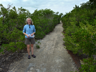
This morning, after hiking the eastern part of the old highway trail (as far as the jumping bridge) we drove to the western part to begin our search for BUNCH. Immediately we noticed the difference between the two sections. While the eastern part is dry and wide open, the western part is much narrower and passes through heavy tree cover from the start. Bugs were nonexistent on the eastern section but were pretty intense here.
After a few hundred yards we emerged from the hammock to a slightly more open trail lined with mangrove instead of hardwood. The trail gained some elevation and we gained some hope that we would soon spot the prairie to the west, despite the fact that we could see only muck and water through the jungle of mangrove branches. The most recent datasheet description refers to a dirt road leading off to the left. This road was under water, but we figured we could simply approach via the main trail and then walk 200 feet west (across the prairie, remember) directly toward the station.
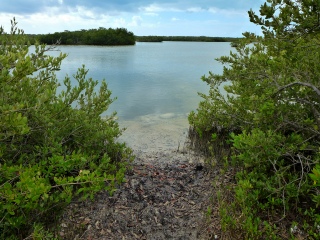
A nice break in the mangroves soon gave us an idea of what that prairie looks like now: it’s under at least several feet of water all the way to the coordinates and beyond! We had a good laugh over that one. I don’t know if it’s due to Florida’s record rains this year or what, but there was no way we were getting to that mark without a boat. And it is clearly submerged now, anyway. Needless to say, we didn’t find the reference marks either. They’re within 30 meters of the station so they are definitely also under water at this time.
We walked a bit longer on the trail before turning back. It’s possible we would have been able to find the azimuth mark, which appears to be much closer to the trail, but with conflicting descriptions on the datasheet we weren’t even sure where to look. Mangrove growth on both sides of the trail is so heavy and close that any kind of search alongside the trail would be difficult.
| Designation | Status | Condition | Image |
|---|---|---|---|
| BUNCH AZ MK | Not Found | Unknown (Not Found) |

|
| BUNCH RM 1 | Not Found | Unknown (Not Found) |

|
| BUNCH RM 2 | Not Found | Unknown (Not Found) |

|


