36 M
Spatial/elevation data
| Coordinates | N 41.657331° W 75.402882° (estimate) |
| Elevation | 1534.949 ft. |
| Location | Pennsylvania
Wayne County Forest City Quad |
Mark description
| Type | Bench Mark Disk |
| Setting | Boulder |
| Monumented | 1942 by USGS |
| Description (USGS) | Waymart; 5.0 mi N. of U.S. Highway 6, along State Highway 296; 340 ft S. of junction of rd. E.; 220 ft NW. of powerline pole 339; 65 ft W. of rd.; in open field; in large boulder; standard tablet stamped “36 M 1942” |
Narrative and photographs
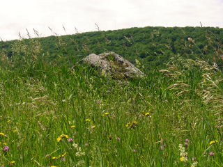
It’s time to mow the fields! We’re not going to attempt the search for 36 M in major tick habitat like this high, heavy grass. We suspect that the disk may be on the only large, prominent boulder in this field, although the rock looks flakier than the type that typically makes for a good bench mark setting. Like 33 M, 36 M may be set in a less prominent but more substantial nearby boulder, nearly flush with the ground. Either way, we’ll wait until the grass is cut, or until wintertime, to try again.

