220 LRP
Spatial/elevation data
| Coordinates | N 41.525612° W 75.205047° (estimate) |
| Elevation | 936.540 ft. |
| Location | Pennsylvania
Wayne County White Mills Quad |
Mark description
| Type | Bench Mark Disk |
| Setting | Bridge Abutment |
| Monumented | 1965 by USGS |
| Description (USGS) | White Mills; 81 ft S. and 31 ft W. of, and 2.4 ft higher than center of bridge over Lackawaxen River; in top of W. end of S. concrete abutment; standard tablet stamped “220 LRP 1965 936” |
Narrative and photographs
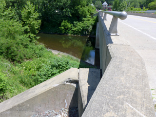
Rich and I spent the late morning and early afternoon poking around the White Mills area. After a stop at the Cactus Man, we drove just a short distance further along Route 6 and then turned onto White Mills Road. Before leaving the house this morning, we just happened to check the topo map and noticed that it indicated a bench mark at the southwest corner of the bridge over the Lackawaxen. It should have been an easy find, but the bridge has apparently been repaired, modified or replaced since 1965. There was no USGS bench mark on any part of the abutment. We did, however, find a relatively new PennDOT disk set into the southeast corner of the bridge (as a further suggestion that the bridge has recently been altered in some way).

