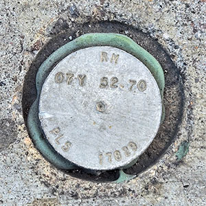
007Y
Spatial/elevation data
| Coordinates | N 36.116866° W 115.1731° (estimate) |
| Elevation | Unknown |
| Location | Nevada
Clark County Las Vegas SW Quad |
Mark description
| Type | Right of Way Disk |
| Setting | Concrete Sidewalk |
| Monumented | Unknown by Clark County Surveyor's Office |
Narrative and photographs
There is a listing on waymarking.com for 007Y (see Las Vegas Strip Right of Way Benchmark #007 Y), and although many of the Las Vegas Strip benchmarks listed there have since been destroyed due to construction, I don’t think that would be the case for this one. However, I simply didn’t spot it for some reason. An associated reference mark is nearby, and it appears to be in good condition.
| Designation | Status | Condition | Image |
|---|---|---|---|
| RM 07Y 52.70 | Recovered | Good |

|
