Portland—Spokane Beacon 3 A: A Personal Connection
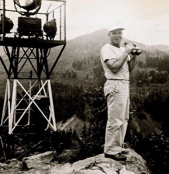
Ray Hays has submitted the following photo of his uncle, Victor Hays (born 1909), with Beacon 3 A along the Portland—Spokane Route (see below for the text of the datasheet, which is now inaccessible via direct link because the mark is considered Destroyed).
This beacon sat atop Beacon Rock in what is now Beacon Rock State Park, along the Columbia River. Beacon Rock is a prominent basalt plug rising to an elevation of nearly 850 feet. A trail of boardwalks and switchbacks provides hikers a path to the summit.
Not much is known about the photo, but Ray suspects that it was taken before World War II. It is the only photo of the beacon that exists in the state park’s archives. I was unable to find any other images of the beacon online.
Beacon Rock has an interesting history. Surprisingly (or at least I was surprised by the coincidence!), it was named Beacon Rock long before the airway beacon was placed there. In fact, it was originally designated Beacon Rock by Lewis and Clark in 1806. By some point in the 1800s—sources vary on the date—the feature was more commonly known as Castle Rock. Then in 1915, the feature’s name was officially changed back to Beacon Rock by the USGS Board on Geographic Names.
The airway beacon was in place at least as early as 1931, as it appears on an airway map from 1931. (It can also be seen on the maps from 1933 and 1934).
The beacon was first observed as an intersection station by the Coast & Geodetic Survey in 1938. And it was destroyed before 2004, as reported by Geocachers and the U.S. Power Squadron. Ray Hays’ friend Ken Cole remembers the beacon up on the rock and thinks it blew over in a bad wind storm in the 1950s. He is quite sure it was before the Columbus Day storm of 1962.
The NGS Data Sheet
*** NOTE - The station below is destroyed.

1    National Geodetic Survey, Retrieval Date = NOVEMBER 27, 2024 11:11:00 EST
RD2119 ***********************************************************************
RD2119  DESIGNATION -  PORTLAND SPOKANE AWY BCN 3 A
RD2119  PID         -     RD2119
RD2119  STATE/COUNTY-  WA/SKAMANIA
RD2119  COUNTRY     -  US
RD2119  USGS QUAD   -  BEACON ROCK (2017)
RD2119
RD2119                         *CURRENT SURVEY CONTROL
RD2119  ______________________________________________________________________
RD2119* NAD 83(1991) POSITION- 45 37 40.41905(N) 122 01 15.91677(W)   ADJUSTED
RD2119  ______________________________________________________________________
RD2119  GEOID HEIGHT    -        -21.952 (meters)                     GEOID18
RD2119  LAPLACE CORR    -          1.37  (seconds)                    DEFLEC18
RD2119  HORZ ORDER      -  THIRD
RD2119
RD2119.The horizontal coordinates were established by classical geodetic methods
RD2119.and adjusted by the National Geodetic Survey in December 1991.
RD2119
RD2119.Significant digits in the geoid height do not necessarily reflect accuracy.
RD2119.GEOID18 height accuracy estimate available here.
RD2119
RD2119.Click photographs - Photos may exist for this station.
RD2119
RD2119.The Laplace correction was computed from DEFLEC18 derived deflections.
RD2119
RD2119. The following values were computed from the NAD 83(1991) position.
RD2119
RD2119;                    North         East     Units Scale Factor Converg.
RD2119;SPC WA S     -    33,884.839   381,385.239   MT  1.00005289   -1 06 17.7
RD2119;SPC WA S     -   111,170.51  1,251,261.40   sFT  1.00005289   -1 06 17.7
RD2119;UTM  10      - 5,053,171.310   576,305.848   MT  0.99967158   +0 41 59.2
RD2119
RD2119_U.S. NATIONAL GRID SPATIAL ADDRESS: 10TER7630553171(NAD 83)
RD2119
RD2119                          SUPERSEDED SURVEY CONTROL
RD2119
RD2119  NAD 83(1991)-  45 37 40.41904(N)    122 01 15.91677(W) AD(       ) 3
RD2119  NAD 83(1986)-  45 37 40.42792(N)    122 01 15.92402(W) AD(       ) 3
RD2119  NAD 27      -  45 37 40.99700(N)    122 01 11.63600(W) AD(       ) 3
RD2119
RD2119.Superseded values are not recommended for survey control.
RD2119
RD2119.NGS no longer adjusts projects to the NAD 27 or NGVD 29 datums.
RD2119.See file dsdata.pdf to determine how the superseded data were derived.
RD2119
RD2119_MARKER: 22 = AIRWAY BEACON
RD2119
RD2119  HISTORY     - Date     Condition        Report By
RD2119  HISTORY     - 1938     FIRST OBSERVED   CGS
RD2119  HISTORY     - 20040430 DESTROYED        USPSQD
RD2119
RD2119                          STATION DESCRIPTION
RD2119
RD2119'DESCRIBED BY COAST AND GEODETIC SURVEY 1938 (WMS)
RD2119'ON SHORT STEEL STRUCTURE.
RD2119
RD2119                          STATION RECOVERY (2004)
RD2119
RD2119'RECOVERY NOTE BY US POWER SQUADRON 2004 (RHC)
RD2119'SITE HAD ONLY FOUR LARGE BENT DAMAGED BOLTS EMBEDDED INTO THE ROCK.
